
United States
El Paso: driving practice routes
Practise driving on the streets of El Paso on a 3D map — free, in your browser, with nothing to install.
Open El Paso in RoadariumThe simulator opens on the city map, where you choose any route.
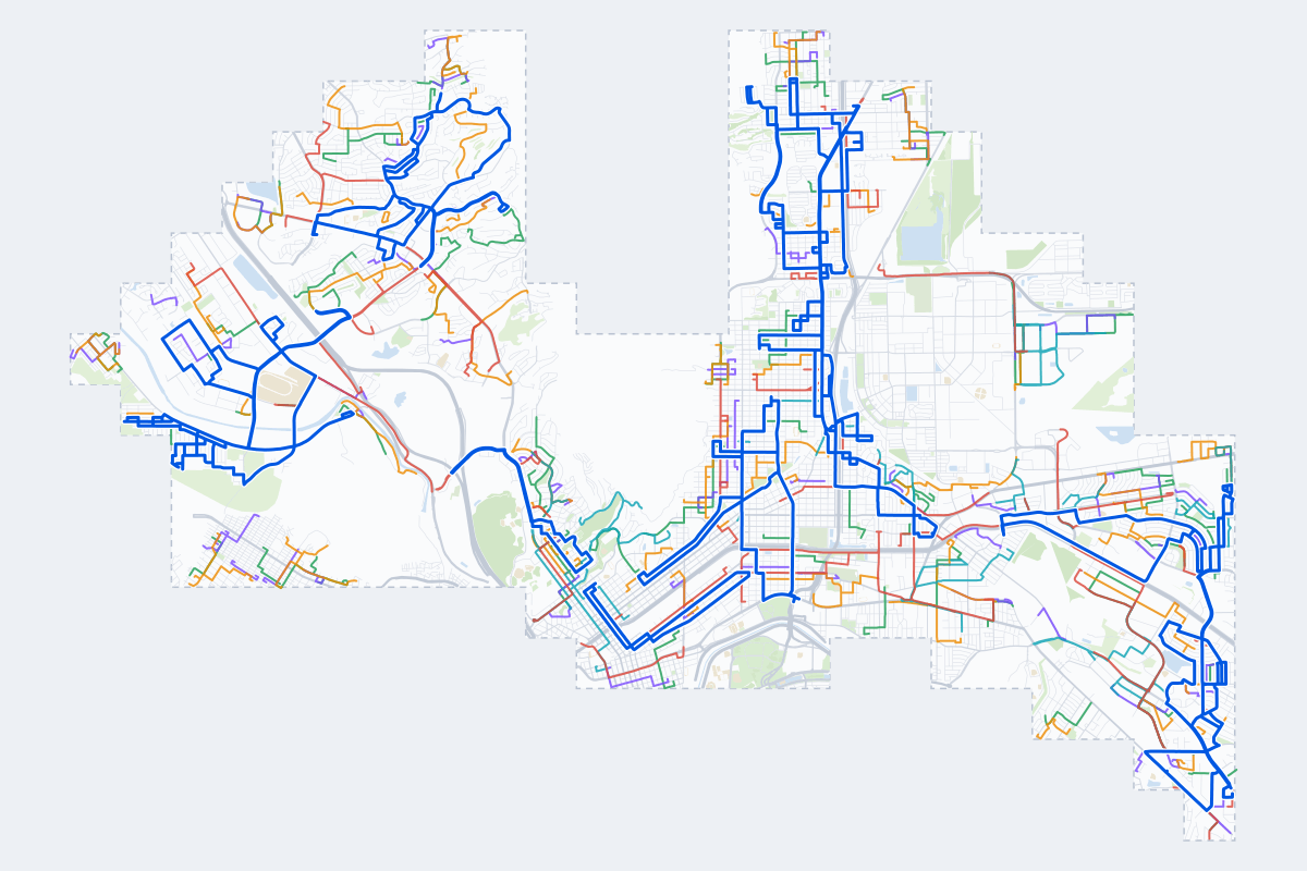
- 285Practice routes
- 498 miLength of all routes
- 28Different roundabouts
- 794Named streets
Route types
| Type | Routes | Typical length | Typical time |
|---|---|---|---|
First driveQuiet streets and simple junctions — a few easy turns | 66 | 1.0 mi | 3 min |
ParkingA short drive that ends in a street with free kerbside bays | 66 | 0.8 mi | 2 min |
JunctionsGive way, STOP and unmarked junctions on the side streets, with turns across the oncoming traffic — who goes first when there are no lights | 62 | 1.2 mi | 4 min |
RoundaboutsOne or more roundabouts on the way | 26 | 2.3 mi | 7 min |
Rush hourBusy avenues through the centre: traffic lights, lanes, turns across traffic | 39 | 2.1 mi | 7 min |
Driving test practiceA drive like the practical test: from a test centre and back where one is known, over the roads and junctions the examiner covers. | 26 | 6.2 mi | 20 min |
Test practice loops
The test drive here lasts about 20 min.
| Loop | Length | Time | Roundabouts | Traffic lights | Turns | Main streets |
|---|---|---|---|---|---|---|
| 1 | 5.3 mi | 17 min | 0 | 8 | 13 | Dyer Street, Magnetic Drive, Hercules Avenue, Kemp Avenue |
| 2 | 5.5 mi | 18 min | 0 | 3 | 15 | Sunland Park Drive, Futurity Drive, Gibson Veck Road, McNutt Road |
| 3 | 5.6 mi | 18 min | 0 | 4 | 18 | McNutt Road, Anapra Road, Alto Vista Drive, El Cerro Drive |
| 4 | 5.7 mi | 18 min | 0 | 12 | 23 | Alameda Avenue, North Carolina Drive, North Loop Drive, Hunter Drive |
| 5 | 5.7 mi | 18 min | 0 | 23 | 12 | Myrtle Avenue, Magoffin Avenue, North Kansas Street, North Campbell Street |
| 6 | 5.8 mi | 19 min | 2 | 13 | 17 | North Mesa Street, Executive Center Boulevard, North Campbell Street, North Virginia Street |
| 7 | 5.8 mi | 19 min | 0 | 6 | 17 | Dyer Street, Polk Avenue, Van Buren Avenue, Byron Street |
| 8 | 5.9 mi | 19 min | 0 | 9 | 19 | North Loop Drive, Hunter Drive, Wilcox Drive, College Circle |
| 9 | 5.9 mi | 19 min | 0 | 12 | 20 | Gateway Boulevard West, West H Burges Drive, Edgemere Boulevard, Hawkins Boulevard |
| 10 | 5.9 mi | 19 min | 0 | 19 | 15 | Copia Street, North Piedras Street, Louisville Avenue, East Paisano Drive |
| 11 | 6.0 mi | 19 min | 0 | 4 | 27 | Westwind Drive, Fountain Road, Pino Real Drive, Los Altos Drive |
| 12 | 6.1 mi | 20 min | 0 | 3 | 21 | Alabama Street, Dyer Street, Kemp Avenue, Volcanic Street |
| 13 | 6.1 mi | 20 min | 0 | 11 | 26 | Dyer Street, Partello Street, Altura Avenue, Gateway South Boulevard |
| 14 | 6.2 mi | 20 min | 0 | 13 | 17 | North Mesa Street, North Stanton Street, Silver Springs Drive, Cloudview Drive |
| 15 | 6.3 mi | 20 min | 0 | 4 | 18 | McNutt Road, Anapra Road, Ocotillo Drive, Meadow Vista Boulevard |
| 16 | 6.4 mi | 20 min | 0 | 13 | 22 | Gateway South Boulevard, Trowbridge Drive, Raynolds Street, Montana Avenue |
| 17 | 6.4 mi | 20 min | 0 | 5 | 18 | Gateway South Boulevard, Dyer Street, Eclipse Street, Hercules Avenue |
| 18 | 6.4 mi | 21 min | 0 | 11 | 25 | Viscount Boulevard, Hunter Drive, Catnip Street, Cuba Drive |
| 19 | 6.5 mi | 21 min | 2 | 12 | 25 | Dyer Street, Frankfort Avenue, Pershing Drive, Radford Street |
| 20 | 6.6 mi | 21 min | 0 | 13 | 22 | Hunter Drive, Viscount Boulevard, Cuba Drive, Lait Drive |
| 21 | 6.7 mi | 21 min | 0 | 7 | 24 | Sunland Park Drive, McNutt Road, Doniphan Drive, Valle Vista Drive |
| 22 | 6.7 mi | 21 min | 0 | 10 | 19 | Dyer Street, Gateway North Boulevard, Ellerthorpe Avenue, Truman Avenue |
| 23 | 6.7 mi | 22 min | 0 | 12 | 15 | Thunderbird Drive, Pino Real Drive, Westwind Drive, Sunland Park Drive |
| 24 | 6.7 mi | 22 min | 0 | 3 | 16 | Alabama Street, East Rio Grande Avenue, North Copia Street, North Piedras Street |
| 25 | 6.8 mi | 22 min | 0 | 3 | 18 | Sunland Park Drive, McNutt Road, Ocotillo Drive, Futurity Drive |
| 26 | 6.9 mi | 22 min | 0 | 18 | 8 | Sunland Park Drive, South Mesa Hills Drive, McNutt Road, Doniphan Drive |
Streets on the routes
The streets the routes of El Paso use most.
- North Mesa Street
- Alameda Avenue
- Dyer Street
- McNutt Road
- North Stanton Street
- Hawkins Boulevard
- North Loop Drive
- Sunland Park Drive
- Alabama Street
- Hunter Drive
- East Yandell Drive
- Founders Boulevard
- Montana Avenue
- Airport Road
- Doniphan Drive
- North Carolina Drive
- Trowbridge Drive
- Butterfield Trail Boulevard
- Leo Street
- Louisiana Street
- Ocotillo Drive
- Phoenix Avenue
- Belvidere Street
- Byron Street
Nearby
How it works
- Open El Paso in Roadarium.
- Pick a route on the city map, or plan your own.
- Drive it in 3D with traffic, signs and lights, then see what to work on.